OTHER REMOTE PILOTED AIRCRAFT SYSTEM SERVICES
LS Multi Copter Projects and Services, a South African based company, was formed to support LS of South Africa Radio Communication Services, an associated company, with airborne RF spectrum and site infrastructure audits locally and internationally.
The company prides itself for its customer requirement sensitivity and specialist offering of a wide range of drone services ranging from high level engineering applications to basic photography.
LS has several aircraft registered with the SACAA, which are all approved within our operation specifications.
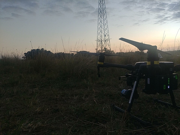
We specialize in in-flight radio frequency measurement using our diverse RPAs fleet These aircrafts ranges from Phantom 4 aircrafts to heavy lift DJI M600 (*RTK) and the state-of-the-art M300 platforms.
Typical Payload could include a 45MP RGB Camera, Lidar Camera, and Thermal Camera.
Our SACAA accreditation, RPAS Operating Certificate (G1269D) and Air Service License (G1228D) is largely recognised internationally where LS has conducted international work in numerous countries across the globe.
LS has done thousands of flights within the border of South Africa, also internationally in Africa, Europe, Asia, South America, and North America.
For more information about our services refer to the poster below and to our LSMC website.
Your LS of SA Contact
Contact us for further information
Phone: +27 (0)11 958 5153
E-mail: Info(at)LSofSA.co.za
Explore RPAS SERVICES: Download Our BROCHURES AND FLYERS

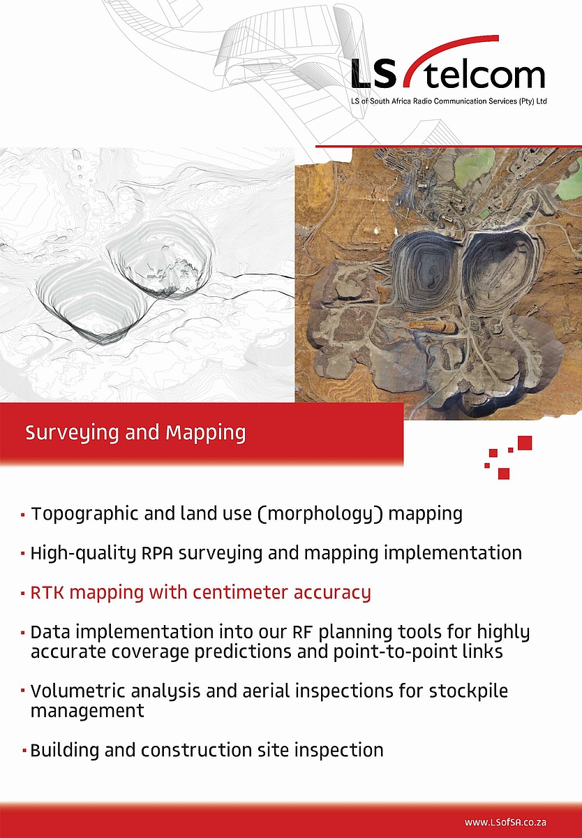

AIRBORNE MAPPING AND SURVEYING
Flight data acquisition for aerial mapping and surveying is done through the recording of high resolution geotagged images for photogrammetric modelling.
MOBILE SITE AUDITS
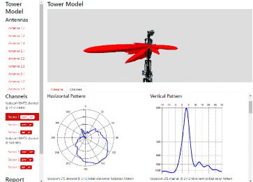
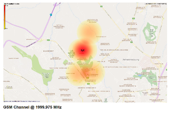
LS of South Africa has the ability to perform Radio Frequency site audits for systems in the frequency band 30 MHz to 30 GHz. We will record information together with high resolution images and information for each transmission on a mast.
This will typically include the following for the mast:
- 3D rendered image of the mast complete with antennas
- Mast Coordinate
- Mast Height
We also include the following per transmission:
- Mid Antenna height
- Beam Direction
- Beam patterns (most instances)
- EiRP
- Transmit frequency
- Channel beamwidth
- Beam tilt
SITE INSPECTIONS
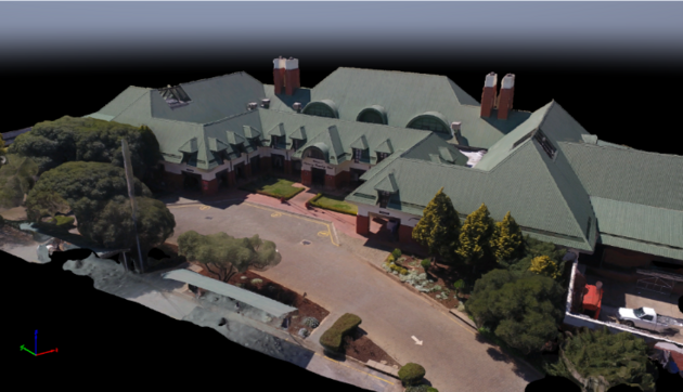
LSMC offers a 3D modelling service whereby the site infrastructure is rendered and represented using photogrammetry. High resolution photographs of all site and mast elements are available for any portion of the 3 D model of the site and this allows the customer to “virtually” scrutinize the 3D rendered model in the comfort of his office.
RF ANTENNA MEASUREMENTS
Transmit and receive antenna installation optimisation
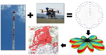
LS of South Africa Radio Communication Services has the ability to perform measurements on antenna systems in order to determine the radiation pattern of both the E and H planes and can determine the gain and direction of such an antenna system.
We can use the measured antenna patterns and gains to ensure that the antenna system is optimised for the maximum coverage area. Such measured antenna patterns can be imported into our planning software to ensure that we achieve the best coverage of the target coverage area. This is important for each transmission network but more so in mining and other critical communication environments. The antenna pattern measurements can currently be performed for the frequency range from 300 kHz to 18 GHz.
DIRECTION FINDING/INTERFERENCE HUNTING
LS of South Africa has the capability to perform interference hunting exercises using portable, mobile as well as drone-based interference investigations. It can also include direction finding using the same platforms.
A general technique called “Angle-of-Arrival (AoA)”, is implemented on an RPAS to be able to track and find a source location of a specified channel. This is to predict possible source of interference locations of channels within a certain measured bandwidth. This is done by doing point rotations at a certain altitude while sweeping through the spectrum.
POWERLINE INSPECTIONS WITH DRONES
LS of South Africa offers smart electrical pylon inspection services to ensure a safe and compliant electrical network infrastructure. By assessing the pylon units with a smart RPAS unit, geotagged images are readily available, combined into a 3D digital twin of the structure.
The typical report will be done by an Electrical engineer and comment and report on the points below:
- Visual and Thermal Images
- Condition of Foundation
- Condition of Steelwork (Missing/Stolen Parts included)
- Condition of Stays
- Condition of Metal work (Coating)
- Condition of Phase Insulators
- Condition of Earthing
- Condition of Anti-Perching Devices
- Condition of Concrete Structures
- Condition of the Conductors
- Condition of Vibration Dampers
- Condition of Corona Rings
- Condition of Tower Labels
- Condition of Compression Joints
- Condition of Arching Horns